Picture this: You’re in the ops center, and storms are moving in. Do you know which ones actually matter?
Not all storms are created equally. Some bring major threats while others just make noise. The real challenge is knowing which is which, and which of your assets are in the crosshairs. What’s the storm’s path? How strong is it? How much time do you have to act?
Baron’s Storm Intel, fully integrated into ArcGIS, delivers the clarity your operations need. New to Baron’s ArcGIS offerings, this suite of ArcGIS-ready weather data products provides real-time storm tracking, impact forecasting, and projected ETAs down to five-minute windows. It cuts through the clutter to highlight storm significance and asset-level threats, turning data into actionable decisions.
Defending Solar Farms from Hail Damage
Renewable energy is your focus. Real-time hail tracking should be too.
For solar operators, hail isn’t just inconvenient; it’s a liability. Panels are often mounted on single-axis tracking systems that follow the sun throughout the day. With Storm Intel in ArcGIS, operators can determine if a hail-producing storm is on track to impact a solar farm and take proactive steps. Using real-time data, panels can be pivoted into an optimal stow position to minimize hail damage, protect equipment, and reduce downtime.
This proactive response not only helps avoid costly repairs and loss of energy production, but can even lower insurance premiums. The entire workflow can be automated within ArcGIS GeoEvent Server or ArcGIS Velocity, making protection fast, seamless, and scalable.
Protecting the Grid Before the Storms Strike
Storms won’t spare your grid, but you can be ready before they strike.
For utility operators, general forecasts aren’t enough. You need to know what kind of storm is approaching, how intense it is, when it will arrive, and which parts of your infrastructure are at risk. With Baron’s Storm Intel in ArcGIS, you can access storm-specific insights that enable proactive planning and faster response.
From substations to transmission lines, utilities can monitor for high-impact threats, alert field crews before severe weather hits, and take action to minimize service disruptions and equipment damage. Whether it’s a tornado, high winds, or hail, Storm Intel helps you respond before an outage happens, not after.
Smarter Alerts for Safer Teams
You’ve got crews in the field, do you know if the storm is headed their way?
Not every storm warrants a full-scale alert. But when the threat includes high winds, damaging hail, or a tornado, your team needs to know immediately.
With Esri’s Field Maps mobile app, organizations can integrate Baron’s Storm Intel data to deliver real-time, location-based alerts directly to workers in the field. When a crew member enters or is near a Storm Intel polygon, such as a storm producing 1" hail or a tornado, they’ll receive a targeted alert. Users can even customize filters based on severity thresholds that match their risks.
At the same time, operations centers using ArcGIS Dashboards can track vehicle locations and overlay incoming storm data from Storm Intel to see which workers are in harm’s way. Since the same dataset powers both Field Maps and dashboard views, teams across the organization stay aligned and informed - supporting faster, more effective decision-making in the face of severe weather.
Trusted Storm Tracking, Now in ArcGIS
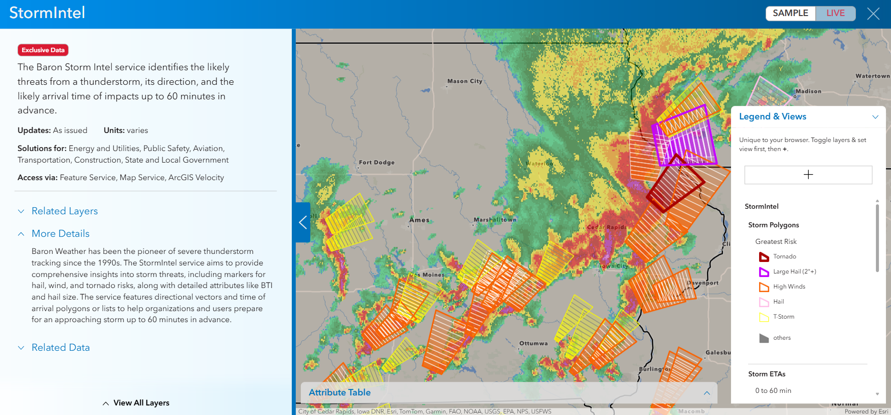
While Storm Intel may be new to Baron’s ArcGIS-ready offerings, the technology behind it has been trusted for decades. Baron Weather has been a pioneer in severe thunderstorm tracking since the 1990s, and Storm Intel builds on that innovation. This feature service delivers comprehensive insights into storm threats, including hail, wind, and tornado risks, along with detailed attributes like Baron Tornado Index and hail size. Directional vectors and time-of-arrival polygons or lists help organizations prepare for approaching storms up to 60 minutes in advance.
Storm Intel isn’t just another map layer, it's a feature service that allows you to create actionable weather insights that integrate seamlessly into your ArcGIS workflows. Whether you’re monitoring assets for high-wind and hail impacts, alerting field crews in severe weather zones, or coordinating utility responses from an operations center, Storm Intel transforms complex weather data into clear, timely decisions that drive safety, efficiency, and loss prevention.
See how our solutions can help your team here.