Nearly every weather app has a radar map. But do you know where that data comes from?
Just because radar data is available doesn’t mean it’s useful. Some of the most critical indicators of severe weather or flooding are often missed when the radar is too far away.
Baron has specialized in building radars for over 30 years, with cutting-edge hardware and software enabling organizations to protect people and property where radar coverage is poor or nonexistent.
The National Weather Service (NWS) operates 160 weather radars in the United States, and over 1,000 government-operated radars are estimated worldwide1. Despite those numbers, nearly 42 million Americans are still underserved, and an estimated 3 to 4 billion of the world’s population live too far from a radar for any coverage2.
Two recent examples highlight the dramatic difference a new, powerful, and sustainable radar has made to the residents of Oklahoma and Colorado. We leverage the power of ArcGIS to demonstrate the benefits each radar has provided to the residents and businesses served by the Baron radar.
The Heart of Tornado Alley – Durant, OK
The Choctaw Nation of Oklahoma, the third-largest federally recognized tribe in the United States, has experienced notable population growth and development over the past decade. Its members, schools, and households have found themselves hundreds of miles from the nearest NWS radar.
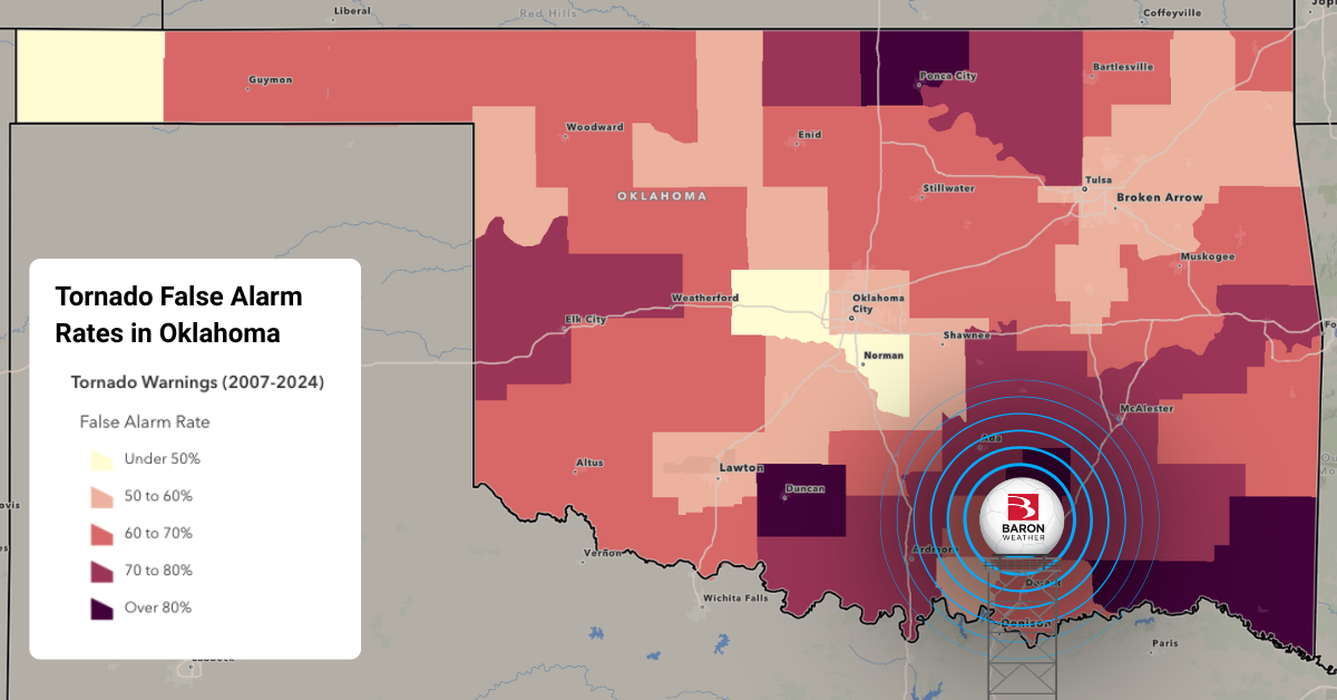
This led to insufficient radar representation for meteorologists at the weather service and on TV to accurately warn residents of southeast Oklahoma of severe weather. The poor radar coverage even contributed to a concerning trend of over-warning its residents.
In coordination with the State of Oklahoma and the City of Durant, Baron provided a new 350 kW C-band radar to detect tornadoes and high-wind events accurately. The numbers speak for themselves.
Installing this radar dramatically reduced the number of underserved people and resources in the Choctaw Nation and surrounding areas. The new Baron radar now reaches over 450,000 people that the NWS radars previously couldn’t adequately cover. This includes those living in over 90 mobile home parks, attending more than 300 schools, and served by more than 25 power plants.
The interactive ArcGIS experience shared below showcases the benefits of the new Baron radar to southeastern Oklahoma.
The City of Durant provides the data free of charge to surrounding communities as a public service, the National Weather Service, Baron Lynx customers, and others.
The Rocky Mountains – Durango, CO
Installing a Baron radar in southwest Colorado addressed a different problem: accurate rainfall and snow estimates. A better detection system helps emergency responders quickly identify potential floods and supports better water resource management between wet and dry seasons.
The tragic 416 Fire in 2018, followed by monsoon floods and mudslides, prompted officials in the area to advocate for the radar. Prior reliance on data from Grand Junction, Albuquerque, and Flagstaff provided an incomplete view, since most storms hitting the area form below 28,000 feet, beneath the range of those radars.
La Plata County partnered with state agencies to install a permanent weather radar near the Durango-La Plata County Airport in 2024. This strategic location allows the radar beam to travel up the Upper San Juan and Animas watersheds and completely cover the San Juan National Forest.
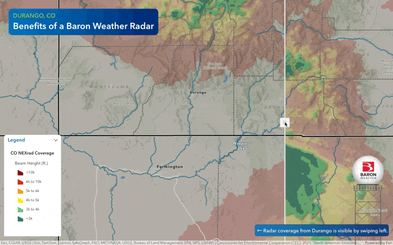
"Since bringing our radar online, we have had insights into approaching weather events in a way that was previously impossible," says Megan Gaham, Strategic Management Director for the La Plata County.
"The radar imagery can show us with previously unavailable precision whether monsoonal storm cells are building over burn scars, which are vulnerable to flooding and debris flow," she added.
The project was primarily funded by a Colorado Department of Local Affairs grant, with additional support from local partners. It ensured better preparedness for fire and flood risks in the region. The radar data is available to the public for free on the web, smartphone apps, or the La Plata County website.
Poor Coverage is a Common Problem
Modern weather apps often conceal the most essential attribute of a radar – its beam height. How far off the ground the beam is at a given location is the strongest indicator of how valuable the radar data is.
The Earth's curvature and topography contribute to degradation in the radar quality the farther you are from the tower. The video below briefly explains how a radar beam can overshoot critical weather hazards such as wind, rotation, hail, or debris.
Radar professionals often use a range height equation to determine when a radar’s beam is too high to be deemed reliable for such hazards. The meteorological consensus is that a beam height over 4000 ft will miss essential severe weather signatures.
Baron’s radar technology advancements are vital for improving weather safety in underserved areas. By filling coverage gaps in places like southeastern Oklahoma and southwestern Colorado, communities can better respond to severe weather events. Investing in reliable radar systems is essential for protecting lives and property and ensuring all communities receive timely and accurate weather warnings.
1 https://tropicalglobe.com/radar_database/
2 https://e360.yale.edu/features/africa-weather-stations-climate-change
